High-Risk Places and Street-Level Context
|
|
This 1:42 minute video shows a risk terrain map for gun shootings as a layer in Google Earth (The map shown here is actually one of the final products from the RTM workshop webinar). Using the "Street View" tool, this video demonstrates how differences between lower-risk places and higher-risk places (as defined by the RTM) can be observed in real terms within the environmental context of micro-level places in Irvington.
RTM is an approach to spatial risk assessment that "paints a picture" of the landscape where crimes are most likely to occur given the spatial influence of certain environmental risk factors. It can articulate perceptions of risk at places beyond merely referencing past occurrences of reported crimes. |
From this basic (and quite "cool") exploration of street-level context and place-based risk, the process of operationalizing spatial influences of crime correlates for use in a risk terrain model seems to be a method with both face validity and statistically significant predictive validity.
So, here's an idea: Create and validate risk terrain maps based upon environmental factors that are currently known to correlate with the specific type of crime (i.e., based on empirical research). Then export the map as a KMZ file and open it in Google Earth Using the 'Street View' functionality of Google Earth, "walk along" the streets in various high-risk and low-risk places to identify new mitigating and aggravated risk factors that might improve your risk terrain model. For example, while doing this with the risk terrain map for shootings in Irvington, we quickly noticed that the environmental context of lower-risk places often included churches or had street intersections with traffic lights nearby. Traffic lights might represent places with higher-than-normal volumes of people/traffic (i.e., more guardianship). Churches in these areas might have mechanisms that create similar deterrent effects on shooting incidents. These mitigating features of the environment could be operationalized to risk map layers, empirically validated, and included in new risk terrain models. Google Earth can provide additional strew-level context to the "first iteration" of maps produced with RTM. (This may be a fun and useful activity to try at CompStat meeting!).
So, here's an idea: Create and validate risk terrain maps based upon environmental factors that are currently known to correlate with the specific type of crime (i.e., based on empirical research). Then export the map as a KMZ file and open it in Google Earth Using the 'Street View' functionality of Google Earth, "walk along" the streets in various high-risk and low-risk places to identify new mitigating and aggravated risk factors that might improve your risk terrain model. For example, while doing this with the risk terrain map for shootings in Irvington, we quickly noticed that the environmental context of lower-risk places often included churches or had street intersections with traffic lights nearby. Traffic lights might represent places with higher-than-normal volumes of people/traffic (i.e., more guardianship). Churches in these areas might have mechanisms that create similar deterrent effects on shooting incidents. These mitigating features of the environment could be operationalized to risk map layers, empirically validated, and included in new risk terrain models. Google Earth can provide additional strew-level context to the "first iteration" of maps produced with RTM. (This may be a fun and useful activity to try at CompStat meeting!).

Once we diagnose the spatial attractors of illegal behavior and crime patterns, we can focus intervention strategies on the places posing the greatest risks -- in an effort to reduce crime by minimizing attractive opportunities for it.
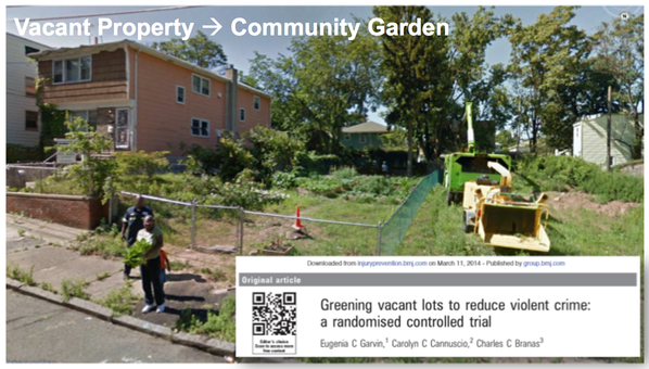
Remember the high-risk area with vacant properties in the Irvington video (above)? Here is a more recent Street View of the same location. In this case, the vacant buildings were replaced with a community garden. This is one example of how police and other stakeholders can mitigate spatial risk factors.
Remember the high-risk area with vacant properties in the Irvington video (above)? Here is a more recent Street View of the same location. In this case, the vacant buildings were replaced with a community garden. This is one example of how police and other stakeholders can mitigate spatial risk factors.
